
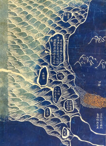
Original images held by the Harvard-Yenching Library of the Harvard College Library, Harvard University
Written by Gang Song 宋剛 (University of Hong Kong)
The Harvard-Yenching Library has a rich collection of more than 9,000 Asian maps. They are invaluable sources for interested Harvard scholars and visiting scholars worldwide to conduct research in history, cartography, and other related fields. Among them, two rare copies of Daqing wannian yitong dili quantu 大清萬年一統地理全圖 (Complete terrestrial map of the Great Qing in eternal unity; ca. 1814) have been attracting a great deal of attention from scholars working on syncretic pattern Chinese world maps in mid-Qing China.
The two maps are almost identical, one mounted on a single sheet while the other in eight panels. The territorial features obviously follow the conventional Hua-Yi 華夷 (Chinese-Barbarian) pattern maps, but a viewer cannot miss the small space at the upper left corner, with islands in the seas representing Xiyang 西洋, i.e., Europe, a visible trace of the “new” geographic knowledge originating from the European-style world maps made by the Jesuit missionaries in China during earlier centuries. Like all other foreign nations, these remote places are depicted as tributary states at the peripheries of the Qing empire, hence providing an idealized depiction of the stereotyped Sinocentric world order.
Technically, the maps present a striking visual effect due to the large-scale application of the Prussian blue colorant. They meanwhile suggest highly sophisticated techniques in rubbing and printing, leaving some unsolved questions for experts of Chinese maps. The unusual color, form, and qualities made them popular maps in pre-modern Asia. As two rare copies in a series of similar “blue maps,” they become unique objects for scholars to make further inquiries into mapmaking in Chinese and global contexts.